The Wave Hiking Guide

Antonio
02-09-2026
 · Travel Team
Lykkers, The Wave is one of the most remarkable sandstone landscapes in the United States.
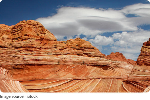
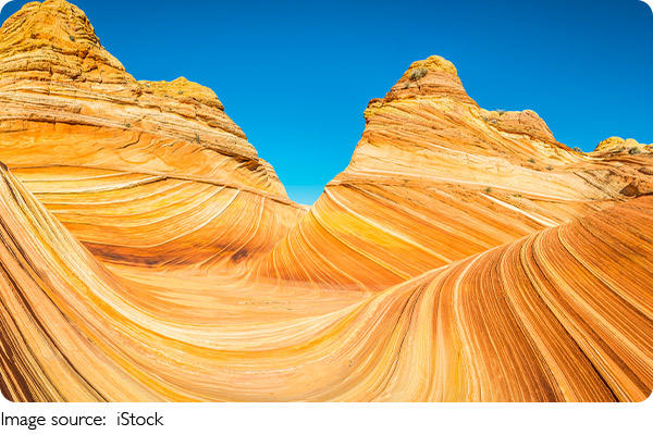
Located in the Coyote Buttes North area near the Arizona-Utah border, it is famous for sweeping layers of red, orange, yellow, and white sandstone shaped into dramatic curves.
Created through millions of years of geological change, the formation offers an extraordinary setting for hiking and photography. Because the area is undeveloped and access is limited, careful preparation is essential.
Coyote Buttes
The Geological Wonder
The Wave is part of the Navajo Sandstone landscape, formed from ancient sand dunes during the Jurassic period. Over millions of years, erosion and weathering sculpted the sandstone into the flowing ridges, curves, and layered surfaces visible today.
A practical guide to hiking Buckskin Gulch, with tips on permits, transport, food, lodging, and weather
A practical guide to Henningsvær, Norway, covering sights, hiking, transport, stays, food, and activities
Where to fish, explore, and experience local life
Queensland port city with gardens, coastal parks, island escapes, and easy day plans—all without crowd stress.
Coral shores, island hops, skyline views—plan a smooth, budget-smart Mactan escape with exact tips.
Small museum with mate history and tastings; staff guide you through the ritual in under an hour.
The natural colors become especially striking where different layers meet. Changing sunlight creates shadows across the contours, revealing patterns that can appear almost fluid despite being solid rock.
The surrounding landscape also contains additional sandstone formations and textures, making the journey itself part of the experience.
Getting a Permit
A permit is required to enter Coyote Buttes North, and daily access is limited to 64 people or 16 groups.
The daily allocation consists of 48 people or 12 groups through advance applications and 16 people or 4 groups through daily applications. The advance application is available several months before the planned hiking date, while the daily application is intended for visitors already within the designated geographic area.
The current application fee is $6, while selected visitors pay a $7 recreation fee per person. These fees are separate.
Because access is limited, travelers with flexible dates may have more opportunities to secure a permit. Once a permit is obtained, transportation and accommodation can be arranged around the confirmed hiking date.
The Hiking Experience
The hike to The Wave is approximately 6.4 miles (10.3 kilometers) round trip. The route crosses undeveloped desert terrain rather than a conventional marked trail, making navigation an important part of the journey.
Loose sand, uneven ground, limited shade, and prolonged exposure to the sun can make the hike physically demanding. Visitors should allow several hours for the round trip and time to explore the surrounding formations.
There is no reliable drinking-water source along the route. Hikers should carry at least one gallon (3.75 liters) of water per person for the day, with additional water considered during warm conditions.
Suitable footwear, navigation equipment, sun protection, food, and basic emergency supplies are also essential.
Best Time to Visit
Spring and autumn are generally popular seasons for hiking because temperatures are often more comfortable than during the hottest part of summer.
Summer can bring intense heat, particularly during the middle of the day. Winter provides cooler conditions but may bring changing weather and road conditions, so checking the forecast before departure is important.
For photography, morning and afternoon light can emphasize the sandstone's curves and shadows. The landscape changes throughout the day, so allowing time to explore different viewpoints can provide a more rewarding experience.
How to Get There
The usual starting point is the Wire Pass Trailhead, accessed from Highway 89 via House Rock Valley Road. A suitable high-clearance vehicle is recommended. Wet conditions can make the road significantly more difficult to travel, so visitors should check current road conditions before driving to the trailhead.
A rental vehicle may cost approximately $60–$120 per day, depending on vehicle type, season, rental period, and availability. Fuel is an additional expense.
The Wire Pass area also has a separate $6 day-use fee per person. This charge is independent of the Coyote Buttes North permit and does not provide access to The Wave.
Where to Stay
The Coyote Buttes North area is an undeveloped wilderness destination, so visitors should stay in a nearby gateway community before and after the hike.
Kanab, Utah, and Page, Arizona, are common bases, offering hotels, restaurants, grocery stores, fuel stations, and other essential services.
Accommodation typically ranges from about $80–$180 per night for many mid-range options, although prices vary by season, availability, and property. During the popular spring and autumn periods, booking in advance is recommended, particularly for travelers with a fixed hiking date.
Where to Eat & Drink
Bring sufficient food and water for the entire hike, as there are no facilities along the route. Stock up in a nearby town before heading to the trailhead.
Fresh fruit and nuts are convenient options to carry, while hikers should bring at least one gallon (3.75 liters) of water per person for the day.
What to Pack
A well-prepared day pack should include:
- At least one gallon (3.75 liters) of water per person
- Navigation equipment and a backup map
- Comfortable hiking shoes
- A hat and sunglasses
- Sun protection
- Fresh fruit and nuts
- A fully charged phone and portable battery
- Basic first-aid supplies
- Weather-appropriate clothing
- A flashlight or headlamp
- Your permit and required identification
Check the weather and road conditions before leaving your accommodation. Because the route crosses undeveloped terrain, hikers should be familiar with their navigation equipment before beginning the journey.
Other Landscapes Nearby
The wider region contains several distinctive sandstone landscapes that can complement a trip to The Wave.
White Pocket features highly sculpted sandstone with intricate patterns and unusual shapes. The Toadstools offer another opportunity to see distinctive desert formations.
Buckskin Gulch provides a different experience, with dramatic sandstone walls surrounding a long, narrow canyon.
These destinations have their own access requirements and conditions, so travelers should research each location separately rather than assuming that a Coyote Buttes North permit provides entry.
Final Thoughts
The Wave combines remarkable colors, flowing sandstone patterns, and a landscape shaped by geological processes over millions of years. Its undeveloped setting makes preparation an important part of the experience.
Secure the appropriate permit, arrange suitable transportation, reserve nearby accommodation, purchase food and water before reaching the trailhead, and check weather and road conditions before departure.
With thoughtful planning and adequate preparation, a visit to The Wave can be a memorable opportunity to explore one of the most distinctive sandstone landscapes in the American Southwest.